In the Icelandic Highlands, a blue line on the map can be more important than the distance. River levels can change with rain, temperature and snowmelt, and many F-roads are only suitable for proper vehicles in the right season.
DULIN highlights river-crossing context, F-road proximity and confidence values where the data supports it. Treat it as an early warning layer: if a place or route shows a possible or required crossing, verify current conditions before you go.
Why F-roads change the whole plan
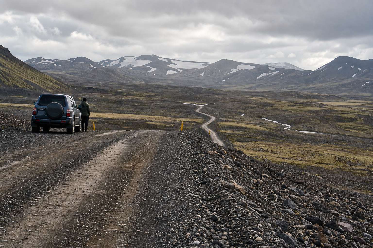
F-roads turn a normal Iceland route into a different kind of decision. A place can look close on the map and still depend on a seasonal mountain road, a legal vehicle class, fresh road openings, rough gravel, poor visibility, one-lane bridges or an unbridged river. That is why DULIN treats access as part of the destination, not as a small note after the fact.
The letter F does not mean a road is easy. It usually means a maintained highland road, but maintenance can be limited to opening, grading and occasional repair. After rain, snowmelt, wind or heavy traffic, the surface can change quickly. Some roads are passable only after late June, some open later, and some close again when conditions deteriorate.
Gravel roads need slower thinking
Even outside the Highlands, Icelandic gravel can surprise drivers who are used to paved roads. Asphalt can end suddenly, loose stones can collect along the edges and middle of the road, and meeting another vehicle may require slowing down or moving carefully toward the shoulder. Blind hills are common, and a crest can hide a curve, a narrow section or an oncoming car.
On loose gravel, speed is the mistake that turns a small correction into a slide. Treat ridges of gravel like a low-traction surface, keep more distance than usual, slow down before bends and bridges, and expect wind, dust or spray to reduce what you can see. The legal speed limit is not the same as a safe speed for the conditions.
What an F-road signal in DULIN means
A F-road or highland-access signal is not a dare and not a guarantee. It means the record deserves a more conservative planning standard. Before adding it to a day plan, check whether the road is open, whether your vehicle and rental terms allow it, whether a river crossing is part of normal access, and whether you still have a safe alternative if you turn around.
DULIN can show F-road routes, road-condition context from Vegagerdin, nearby public cameras, weather observations, river-crossing notes and mobile-signal estimates. Use those signals to decide what needs verification; do not use them as a replacement for official road status, weather forecasts or local judgment.
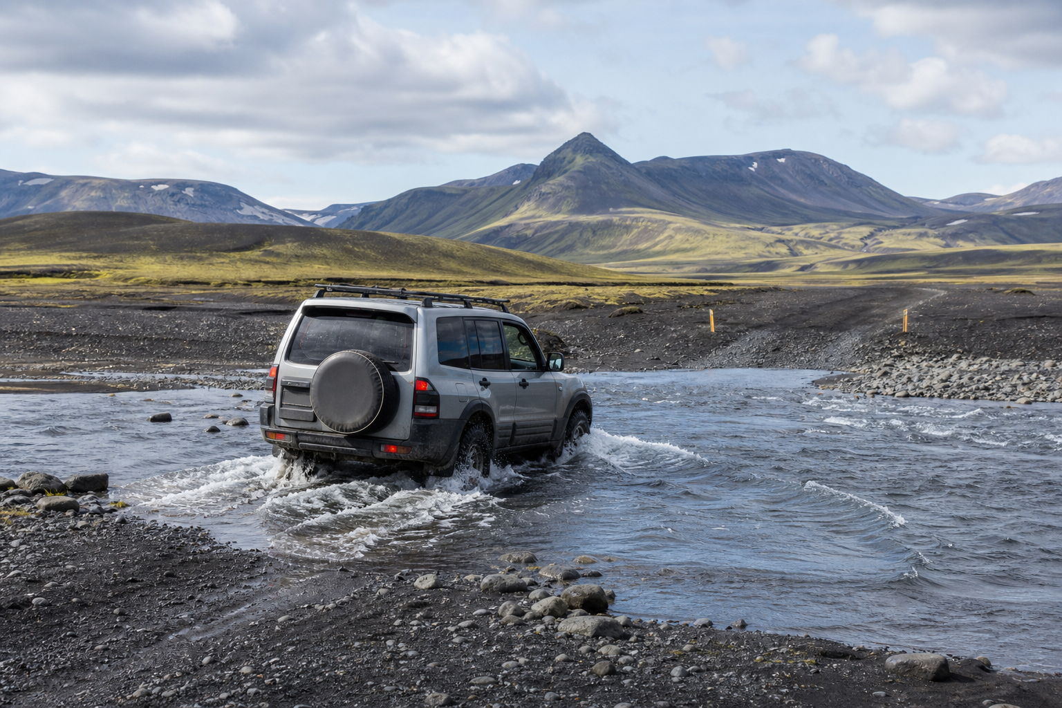
River crossings are not fixed obstacles
A ford can be shallow in the morning and more serious later the same day. Glacial rivers can rise with warmth and meltwater, rain can change depth and current quickly, and the safest line through the water may shift with sediment and stones. The question is not only “how deep is it?” but also current, bottom surface, exit route, vehicle clearance and what happens if you stop in the middle.
Throwing stones into a river or judging from the bank can miss deeper channels and soft spots. If the crossing is unclear, fast, rising, deeper than expected or beyond your experience, the right decision is to turn around. It often takes more discipline to abandon a plan than to continue, but that is exactly the judgment Iceland highland travel requires.
- None means DULIN has no known crossing signal for typical access, not a guarantee.
- Possible means a ford, F-road context or route clue suggests extra checking is needed.
- Required means the data indicates a crossing is likely part of normal access.
- Unknown means the database does not have enough confidence yet.
Off-road driving is not an option
In Iceland, driving off roads and marked tracks is illegal and can cause damage that lasts for years or decades. Volcanic soil, moss, sand and fragile vegetation recover slowly, and one set of tire marks can become an erosion channel or encourage more damage. If a track becomes unsuitable, turn around or continue on foot where that is allowed.
This matters for F-road planning because highland terrain can make a shortcut look tempting. Do not create your own line around water, mud, snow or a damaged section. Stay on marked roads and tracks, respect closures, and treat seasonal restrictions as part of the route.
A practical pre-trip checklist
Use DULIN to flag records that need extra verification, then verify with official sources before departure. Check the route in daylight, carry a backup plan, and never let a saved pin pressure you into continuing when water, wind or visibility feels wrong.
- Check current road status before leaving paved or lowland roads.
- Check weather for wind, precipitation, temperature and meltwater trends.
- Look at nearby public cameras where available.
- Confirm that your vehicle, tires, insurance and rental terms allow the road.
- Carry enough fuel margin for turning around or rerouting.
- Keep headlights on, use seat belts and never mix alcohol with driving.
- For remote or difficult highland tracks, travel with another capable vehicle where appropriate.
- Turn around early if a crossing is unclear, rising, fast or deeper than expected.
When to make the decision
The worst time to decide whether a highland road is suitable is at the river edge, late in the day, after investing hours into the approach. Make the main decision before the rental desk, refine it the night before, and check again on the morning of travel. If the official road status, weather, camera view or your own fatigue changes the equation, choose the easier option.
Emergency help in Iceland is reached through 112, but responsible planning means avoiding the situation where you need it. DULIN is designed to help you notice weak points in the plan early: F-road dependency, river crossings, remote services, mobile-signal gaps and lack of nearby backup stops.
How DULIN helps
DULIN does not try to replace local judgment. Its job is to show early signals: road access category, F-road planning layer, possible river-crossing status, live road-condition context where matched, nearby routes, nearby places, weather observations and public cameras. That lets you identify which stops need more research before you spend the day driving toward them.
Use DULIN as a planning layer, then verify with Road.is, Umferdin road conditions, SafeTravel Iceland and Vedur weather forecasts.
River crossing data is a warning layer
Use the river crossing guide to recognize when extra verification is needed. It should help you slow down before the trip, not make you more confident at the river bank.
Open the map when you need to compare nearby places, hikes, road access, weather context and saved trip items.